Curzon has a renowned history as a family name in Derbyshire, having been lords of Kedleston since the 12th century. There is a direct connection with the family but first we should trace the history of the land on which Curzon Street
was built.
Long Eaton was not always ‘Long’; it gained that part of its name sometime between its entry in the Domesday Book of 1086 and when it was first recorded as Long Eaton two hundred years later. Although no record of the settlement
exists before we were conquered by the Normans, the name Eaton (written as Aitone in Domesday) suggests that it was founded by settlers that we call Anglo Saxons emigrating from what is now north western Germany and southern Denmark
following the departure of the Romans in the 5th century. The language they spoke was the forerunner of both English and Danish.
The founders of the settlement were agriculturalists and brought their system of farming with them. Their system was to have a core settlement of families grouped together in the centre of a field system which could be cultivated
within easy reach of the farmsteads. Traditionally there were three arable fields to each settlement where crops were grown in rotation, with each field under cultivation carrying a common crop. Each family had a number of sections
of the field, called ‘lands’ – or around here ‘lants’ – for their individual use. There would also be common pastures where cattle would graze and meadows where hay would be grown for winter livestock feed.
The land where Curzon Street is situated was in the largest section of an open arable field called Upper Field which covered an area bounded by Derby road to the south, the township of Sandiacre to the north, the hamlet of Wilsthorpe
to the west (now delineated by the ends of the gardens on the west side of Briar Gate) and to about where Wellington Street was later built in the east. This field was in multiple ownership of the villagers for over a thousand years
until, in 1765 an Act of Parliament was passed to enclose the fields and commons of Long Eaton. The fields were then divided up and apportioned into individually owned plots in proportion to the ownership of existing holdings and
rights.
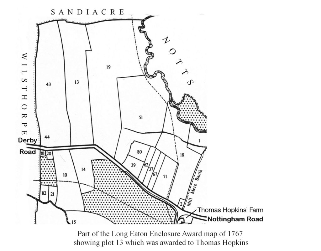
The enclosure Award gave the land where Curzon Street and Breedon Streets lie to Thomas Hopkins, a farmer whose home and farm buildings were at the northern extremity of the village, an area known in more recent times as The Beeches and where Wilko is now situated. Hopkins was a substantial farmer who was awarded 121 acres of freehold land from the total of 1788 acres enclosed. Hopkins’ allotment on Derby Road was subsequently fenced into 3 separate closes named (from Derby Road): Derby Way Close, (12 acres); Middle Field, (14 acres) and Sandiacre Hedge, (12 acres). Sandiacre Hedge is an interesting name; that is how it was written in the first known record but later on it was known as Sandiacre Edge. Both names seem appropriate. Hopkins’ heirs continued to own the land until it was sold to John Curzon about 1850.
John Curzon already owned land in Long Eaton including the Manor Farm where Acton Road is now situated. His property was acquired for investment and was leased to local farmers. John, a Derby solicitor, was the great great grandson of Richard Curzon of Breedon-on-the-Hill who was the brother of Sir John Curzon, MP (1598-1686) of Kedleston, the first Baronet.
By 1880 Long Eaton’s lace and railway industries were booming and the town was expanding to the west along Derby Road, not only with new factories but also with housing. John Curzon had died in 1864 but his son and heir, Nathaniel Charles Curzon of Breedon-on-the-Hill and Lockington, a barrister and High Sheriff of Derbyshire, clearly saw the potential for development and appointed John Sheldon, a Long Eaton surveyor, architect and estate agent, to act for him.
In Derby Way Close Sheldon laid out two streets, Breedon Street and Curzon Street for a distance of 420 ft (128m). He also laid out Nathaniel Road on the Manor farm estate. The land abutting Derby Road was divided into building plots: on Derby Road there were 8 plots, 2 on each side of both streets. Behind them were 6 plots up either side of the new streets. See plan here. On 13 March 1883 the plots were auctioned at the Old Bell Inn (‘Top House’), now Al Naseeb in Market Place, Long Eaton. Five plots were sold on the day, only one of which was in Curzon Street – the plot which is now house number 2, bought that day by George Longden for the sum of £141-7s-6d (£141.375). The remaining plots were subsequently sold by private treaty.
The take-up was relatively slow and by 1896 only 8 houses had been built in Curzon Street. Nathaniel Curzon died in 1897 and his brother and heir, William Curzon decided to sell all his estates in Long Eaton. William appointed architect Ernest Hooley to act for him and the next sections of both Curzon and Breedon Streets were laid out as far as the Sandiacre boundary. This area of land was divided into three lots: lots 9 and 10, described as ‘Valuable building land’, extended the streets by a further 625 feet (190m) to the end of Derby Way Close where Canal Street was laid out. Lot 11 comprised the two closes, Middle Field and Sandiacre Edge, described as ‘Arable or Garden Land’. See plan here (2).
Lots 1 to 8 were the various parts of the Manor Farm estate. All the lots were auctioned at the Royal Hotel, Long Eaton on 13 March 1899, ending the Curzon family’s relatively short association with the town but leaving a legacy of the three street names: Curzon, Breedon and Nathaniel.
Lots 9, 10 and 11 were bought by the Long Eaton Mutual Land Society. Lots 9 and 10 were set out by the Society into 60 plots, 30 in each of Curzon and Breedon Streets. In Curzon Street these plots became, on the west side, houses numbered 25 to 71 and on the even side, numbers 22 to 82. See plan here.

The two closes north of Canal Street were similarly laid out for both streets with 207 plots. On Curzon Street they were numbered 102 to 153 on the east side and 154 to 207 on the west side, representing the houses now numbered 84 to 256 on the even side and 87 to 293 on the odd side. See plan here.
A register of those who purchased these lots has survived and where they can be tied to a particular house, details are given in the Development spreadsheet. link
By 1913 there were 110 houses in occupation but building stopped in 1914 for the duration of the first World War. Only a relatively small number of men from the street are known to have been on war service, 11 in all and four of them never returned. See the complete list here.
During the 1920s and 1930s building continued apace and by 1939 there were nearly 200 houses in the street. At the outbreak of the Second World War the Government introduced National Identity Cards by registering everyone in the country. These registers survive and the records for Curzon Street are listed here [link].(7) Most of those still alive and younger than 100 in 2007 have been redacted.
As can be inferred from the old field name ‘Sandiacre Edge’, the northerly close took the development of Curzon Street to the Long Eaton Urban District’s boundary with Sandiacre. The projected end of the street became a dead end only a short distance from Longmoor Road. It is evident that shortly after the turn of the 20th century a street plan was laid out in Sandiacre which extended College Street and Curzon Streets to Longmoor Road, Breedon Street to College Street and Ravensdale Avenue from Curzon Street to College Street. It was on this layout that in 1910, Moorlands was built on Curzon Street by the Long Eaton lace machine builder John Spridgeon. The gardens of Moorlands originally extended south to abut the Long Eaton boundary on the west side of Curzon Street.

In 1921 the boundaries of Long Eaton were extended to the north to include that part of Sandiacre south of the Derby Canal. On the west side, number 293 was the last house built short of the boundary and the street name plate on this house survives. Today, the old boundary between Long Eaton and Sandiacre can be seen on the ground marked out by a wall, built at a slight angle to the street, between numbers 256 and 258.
Following the expansion, the LEUDC bought an area of newly acquired Sandiacre land bounded by Curzon Street on the west, Breedon Street on the east and Ravensdale Avenue on the north. Here the Council built an estate of 22 semi-detached houses which include numbers 258 to 270 Curzon Street.
Apart from a hiatus during WW2, building has continued in the street to the present day and this year (2020) has seen the first re-development, when number 287 was demolished. This house, erected in 1921, was a Government surplus Army hut, originally timber framed, corrugated iron clad, asbestos cement lined, and roofed with asbestos cement tiles. The proposed replacement is for a pair of semi-detached houses having four parking places on the front – not an asset to the street scene.
Records of the history of the land which was formerly in Sandiacre have not been located so if anyone in this area has house deeds, the author is keen to have sight of them to add to our knowledge of the street’s history.
Any errors in this account are my responsibility and please bring them to my attention.
Keith Reedman
107 Curzon Street
December 2020